Production year
2020

© Stéphane JAILLET / EDYTEM / CNRS Images
20210137_0017
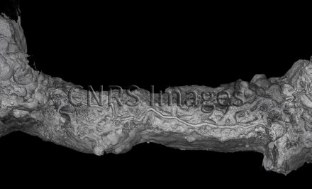
The image shows a bird’s eye view of one of the galleries of the Grotte de la Madeleine cave, located in the heart of the Gorges de l’Ardèche in southern France. This was entirely scanned using ground-based lidar, also known as 3D laser scanning, which makes it possible to “see” from the outside and thus identify features formed in the past. This technology provides an unprecedented overhead view (or nadir view) of the ceiling of the gallery and its astonishing formations, testifying to the erosion that created these imposing shapes several million years ago. This technique provides very high-resolution 3D-images of sections of such cavities, although it cannot be used to uncover new ones. The very detailed maps produced in this way enable scientists to explore underground environments that can sometimes be impossible to access. This image is a winner of the 2021 La preuve par l'image (LPPI) competition.
The use of media visible on the CNRS Images Platform can be granted on request. Any reproduction or representation is forbidden without prior authorization from CNRS Images (except for resources under Creative Commons license).
No modification of an image may be made without the prior consent of CNRS Images.
No use of an image for advertising purposes or distribution to a third party may be made without the prior agreement of CNRS Images.
For more information, please consult our general conditions
2020
Our work is guided by the way scientists question the world around them and we translate their research into images to help people to understand the world better and to awaken their curiosity and wonderment.