Research program(s)
Production year
2018

© Franck LAVIGNE / LGP / CNRS Images
20220016_0009
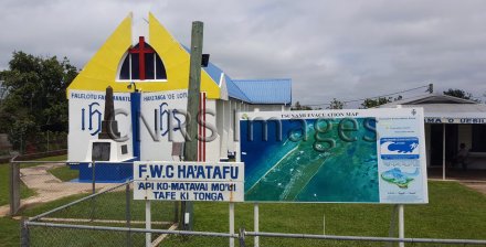
Panneau avec une carte d'évacuation en cas de tsunami, devant une petite église, à l'ouest de Tongatapu, une île de l'archipel des Tonga. Cette photographie a été réalisée en 2018 lors du programme TongaPAG financé par le labex DynamiTe dans le cadre des actions de soutien à la recherche (SAR-Dyn). L'objectif était de travailler sur les paléotsunamis dans l'archipel des Tonga. L'équipe scientifique a fait le lien entre les légendes locales et un grand tsunami qui a eu lieu a priori au 15e siècle.
The use of media visible on the CNRS Images Platform can be granted on request. Any reproduction or representation is forbidden without prior authorization from CNRS Images (except for resources under Creative Commons license).
No modification of an image may be made without the prior consent of CNRS Images.
No use of an image for advertising purposes or distribution to a third party may be made without the prior agreement of CNRS Images.
For more information, please consult our general conditions
2018
Our work is guided by the way scientists question the world around them and we translate their research into images to help people to understand the world better and to awaken their curiosity and wonderment.