Research program(s)
Production year
2013

© Jimmy ZWIEBEL/LAMP/CNRS Images
20150001_0356
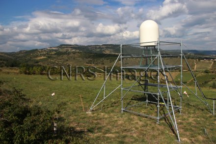
Radar bande X à haute résolution spatiale et temporelle (90 m et 3 minutes) déployé au pied des Cévennes à 268 m d'altitude. D'une portée de 20 km, il permet d'effectuer un scan sur trois élévations, afin de suivre l'évolution des systèmes précipitants et d'estimer les pluies correspondantes. Cet appareil a été déployé dans le cadre de la campagne internationale HyMeX, dédiée au cycle hydrométéorologique en Méditerranée. A l'occasion de cette campagne, un important dispositif de télédétection radar et de mesure des précipitations a été déployé dans la région du nord des Cévennes. L'objectif était d'étudier la structure et l'hétérogénéité spatio-temporelle fine des précipitations, en interaction avec le relief montagneux.
The use of media visible on the CNRS Images Platform can be granted on request. Any reproduction or representation is forbidden without prior authorization from CNRS Images (except for resources under Creative Commons license).
No modification of an image may be made without the prior consent of CNRS Images.
No use of an image for advertising purposes or distribution to a third party may be made without the prior agreement of CNRS Images.
For more information, please consult our general conditions
2013
Our work is guided by the way scientists question the world around them and we translate their research into images to help people to understand the world better and to awaken their curiosity and wonderment.